


There is a particular kind of magic that happens when a century-old machine still does exactly what it was built to do. In Pittsburgh, that magic runs on cable and steel, up the face of a hillside, twice a day, every day, carrying locals and tourists alike from the valley floor to the ridgeline above. The city has two working inclines left — the Duquesne and the Monongahela — and they are, without exaggeration, among the most underrated pieces of working transportation history in the entire United States.
This is not a nostalgia piece. Pittsburgh’s inclines are not preserved behind museum glass. They move. They creak. They carry passengers. And understanding why they still exist, and why they matter, tells you something essential about what Pittsburgh actually is.

The City That Had to Solve a Vertical Problem
Pittsburgh was built in a geographic chokehold. The confluence of the Allegheny, Monongahela, and Ohio rivers created natural industrial opportunity — flat land near water was where the mills, the foundries, and the commerce went. But workers needed somewhere to live, and the only available land was up. The hillsides surrounding Pittsburgh, known locally as “the bluffs,” became densely populated neighborhoods almost by necessity.
Walking those hills was brutal. The slopes aren’t gentle. They’re the kind of grade that turns a three-block walk into a cardiovascular event. By the 1870s, as Pittsburgh’s industrial population swelled, the city had a serious logistical problem: how do you move people efficiently between the valley and the hillside neighborhoods above?
The answer, borrowed from European funicular technology, was the inclined plane railway — a cable-powered car that rides a fixed track up the face of a hill, counterbalanced by a descending car on a parallel track. At its peak in the late 19th and early 20th centuries, Pittsburgh had seventeen operating inclines. Seventeen. Running on multiple hills across the city, serving thousands of daily commuters, they were as normal a part of Pittsburgh life as the streetcar was to other American cities.
Today, two remain. And the story of how they survived when fifteen others did not is worth telling carefully.
The Monongahela Incline — America’s Oldest Operating Funicular
Open the history books and the Monongahela Incline has a clear claim to fame: it is the oldest continuously operating funicular railway in the United States. It began service on May 28, 1870, designed by engineer John Endres and financed by a group of businessmen who understood that the South Side Slopes neighborhood above needed a reliable connection to the city below.
The original design was powered by a stationary steam engine. The cable wound around a drum at the top station, pulling the car upward while the weight of the descending car provided counterbalance. It was an elegant mechanical solution — practical, reliable, and genuinely useful to the working-class families who lived on the hillside.
Over the decades, the Monongahela Incline survived several modernization efforts. Steam gave way to electric power in the 1880s. Cars were rebuilt and updated. But the fundamental principle — two cars on parallel tracks, connected by a cable over a central sheave wheel — remained unchanged from the original conception. There is something philosophically satisfying about that continuity.
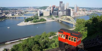
Today the Mon Incline, as it’s locally known, runs 635 feet along a grade of approximately 35 degrees, lifting passengers from West Carson Street at the base to Grandview Avenue at the top. The ride takes about ninety seconds. Those ninety seconds deliver one of the best views in any American city.
At the upper station, Grandview Avenue earns its name. The view from the Mount Washington neighborhood — Pittsburgh’s skyline, the three rivers converging, the bridges crossing in every direction — has been called one of the most spectacular urban vistas in the world. The National Geographic Society once named it among the ten most beautiful views from a city. The Mon Incline puts you there in under two minutes from street level.
The Duquesne Incline — Saved By the People Who Rode It
If the Monongahela Incline is Pittsburgh’s storied elder, the Duquesne Incline is its scrappy survivor. Built in 1877, designed by Samuel Diescher (the same engineer who designed several of Pittsburgh’s other inclines), the Duquesne runs from West Carson Street to Grandview Avenue — parallel to the Monongahela, roughly a mile to the west.
For most of its history, the Duquesne Incline ran without incident. But by 1962, it was slated for demolition. The Duquesne Incline had become unprofitable, ridership had declined, and the operators announced they were closing it permanently. This is the fate that claimed all fifteen of the other Pittsburgh inclines — obsolescence followed by dismantlement.
What happened next was unusual. A group of neighborhood residents — local people who depended on the incline and cared about its preservation — formed the Society for the Preservation of the Duquesne Heights Incline and took over operation of the railway. They fundraised. They fixed the equipment. They kept the cars running.
That organization still operates the Duquesne Incline today. It is, remarkably, a non-profit community operation rather than a city agency or a private corporation. The original wooden cable cars — built in 1877 and still in service — have been lovingly maintained, their interiors preserving the Victorian-era aesthetic with ornate woodwork and antique fixtures. The upper station houses a small museum dedicated to Pittsburgh’s incline history, with photographs, artifacts, and mechanical displays that explain how the system works.
The Duquesne’s survival is a story about civic attachment — about people deciding that some things are worth the trouble of keeping.
How an Incline Actually Works
Strip away the romance for a moment and consider the engineering. An inclined plane railway is mechanically simpler than it looks, which is part of why these machines have lasted so long.
Two cars sit on parallel tracks on the hillside. They are connected by a single cable that runs over a sheave wheel — essentially a large pulley — at the top of the incline. When car A descends, its weight pulls car B upward. The electric motor at the top station provides the additional power needed to overcome friction and weight imbalance, particularly when one car is carrying more passengers than the other.
The tracks are fixed — there is no steering, no navigation. The cars simply move up and down their respective rails, guided by the fixed geometry of the track. This simplicity is also reliability. There are no complex hydraulics, no computer-controlled switching, no diesel engines to service. The main points of failure are the cable, the sheave wheel bearings, the braking system, and the electric motor — all of which are visible, accessible, and straightforward to maintain.
Both Pittsburgh inclines undergo regular cable inspections and replacements. The cable is the critical component, and modern cable technology has improved substantially since the 1870s. But the mechanical principle is identical to what Samuel Diescher and John Endres designed 150 years ago.
The Neighborhoods They Serve — And Why That Still Matters
It would be easy to dismiss Pittsburgh’s inclines as tourist attractions wearing the costume of functional transit. That dismissal would be lazy and wrong.
Mount Washington, the neighborhood at the top of the Monongahela Incline, is a real residential community. People live there. Some of them use the incline to get to work or to reach the South Side below, particularly in winter when driving the steep hillside roads becomes genuinely hazardous. The Duquesne Heights neighborhood at the top of the Duquesne Incline is similarly inhabited, similarly lived-in.
These aren’t theme park destinations with a veneer of residential authenticity. They’re neighborhoods that grew up around the inclines because the inclines made them accessible. The relationship runs the other way from how most tourist infrastructure works — the tourists came to the inclines because the inclines were already doing something useful.
That utility matters for another reason: it explains why the community organizations and transit authorities that support these lines have a genuine, non-sentimental reason to keep them operational. When an ice storm makes the hillside roads impassable, the incline remains a reliable route. That practical argument has kept public investment justified for decades.
The Fifteen That Didn’t Survive
Acknowledging the survivors requires acknowledging the losses. Of the seventeen inclines that once operated in Pittsburgh, fifteen are gone.
The list is a catalogue of different endings. Some inclines closed during the Great Depression, victims of reduced ridership when unemployment gutted the working-class communities they served. Others fell to the automobile — as cars became affordable and roads were improved, the case for waiting on an incline schedule weakened. The construction of the Liberty Tubes and other tunnels through Pittsburgh’s hills provided alternative routes that undermined incline ridership.
The last of the lost inclines — the Castle Shannon Incline — closed in 1964, just a year after the community effort saved the Duquesne. Its tracks were torn up and the hillside returned to vegetation. You can still see the scar on aerial photographs if you know where to look.
The pattern of loss is familiar to anyone who has studied urban transit history: incremental decline, deferred maintenance, a tipping point of unprofitability, and then closure. What made the Monongahela and Duquesne different was timing, community attachment, and — in the Monongahela’s case — its connection to a transit authority with resources to maintain it.
Photography, Light, and Why Everyone Has the Same Shot
There is a photograph that virtually every visitor to Pittsburgh takes from the top of either incline. The skyline from Grandview Avenue, with the rivers spreading out below and the downtown bridges arranged in a kind of accidental geometric perfection, is one of those compositions that almost takes itself. The light at golden hour — late afternoon, when the sun drops behind the hills to the west and catches the downtown glass towers at a low angle — turns the city into something that looks almost implausibly cinematic.
The inclines are partly responsible for this. By placing an accessible viewpoint at the top of Mount Washington, they created a democratic overlook — not just for wealthy homeowners with hillside views, but for anyone willing to pay a few dollars and ride ninety seconds upward. The view from the top of the Duquesne Incline is slightly different from the Monongahela’s perspective, more westward-facing, catching the Ohio River as it leaves the city. Serious photographers ride both.
The best light for the skyline shot is winter, counterintuitively. Leafless trees don’t obstruct sightlines, and low-angle winter sun creates dramatic shadows on the downtown bridges. The worst light is midday in summer, when the city flattens into haze and direct overhead light strips out the texture that makes the view interesting.
What the Inclines Reveal About Pittsburgh’s Character
Cities develop their identities around the problems they’ve had to solve. New Orleans developed its cuisine partly from the creative necessity of cooking in a hot, humid climate with limited refrigeration. Chicago’s grid system reflects the ambitions of a city that rebuilt itself from scratch after fire. Pittsburgh’s inclines are a physical expression of the city’s willingness to engineer its way around a difficult landscape rather than surrendering to it.
That same quality shows up elsewhere in Pittsburgh’s urban fabric: in its 446 bridges (more than Venice, a fact Pittsburghers will tell you with undisguised pride), in the tunnels that run under the hills, in the way neighborhoods perch on seemingly impossible hillside angles and function anyway. Pittsburgh is a city that has consistently refused to let geography limit it.
The inclines fit that character. They are a refusal — an insistence that “this hillside is too steep” is a problem to be solved, not a constraint to be accepted. The fact that two of them are still running, 150 years after the oldest one opened, is not a historical accident. It is a deliberate choice, renewed every year through maintenance budgets and community fundraising and the quiet daily decision of residents to use them.
Visiting the Inclines — Practical Notes
Neither incline requires advance booking or complex planning. Both operate daily, with reduced hours on weekends. The lower stations are accessible from West Carson Street, which runs along the south bank of the Monongahela River in the South Side neighborhood. Street parking is available nearby, and both stations are accessible by Pittsburgh Regional Transit bus routes.
The Monongahela Incline accepts Port Authority transit cards and cash. The Duquesne Incline operates independently and accepts cash and card at the lower station ticket window.
At the top, Grandview Avenue offers several restaurant options, particularly along the stretch above the Monongahela Incline where the view restaurants cluster. For the best unobstructed view, walk west from the Mon Incline’s upper station toward Grandview Overlook Park — a public viewing area with benches and railings positioned for the classic Pittsburgh panorama.
The Duquesne Incline’s upper station museum is free with your incline fare. Allow fifteen minutes to walk through it — the display of historic photographs and mechanical equipment is more interesting than its modest footprint suggests.
One practical note that guidebooks sometimes miss: riding both inclines in the same visit is not as straightforward as it sounds, because they are separated by roughly a mile along Grandview Avenue. Walking between upper stations takes about twenty minutes. If you plan to ride both — and you should — factor that into your timing.
The Future of the Inclines
No piece of 150-year-old infrastructure can be considered unconditionally permanent. Both inclines require ongoing investment. Cable replacements, track maintenance, station upkeep, and the general expense of operating Victorian-era machinery in a 21st-century regulatory and insurance environment add up.
The Monongahela Incline, operated by the Port Authority of Allegheny County, benefits from the stability of a public transit operator’s budget — though public transit funding is perpetually contested in Pennsylvania, as it is most places. The Duquesne Incline’s non-profit operator faces the perennial challenge of smaller organizations: dependence on ticket revenue, donations, and grant funding that can fluctuate.
In recent years, Pittsburgh’s tourism growth has been a net positive for both lines. The city has experienced a sustained economic and cultural revival since the decline of the steel industry — universities, medical centers, technology companies, and an arts scene have filled some of the void. More visitors mean more incline riders, which means more revenue and more public attention to the lines’ condition.
There is also a broader argument emerging in urban planning circles that inclines and funiculars deserve reconsideration as transit solutions in hilly cities. As cities look for low-emissions, space-efficient transit options, the inclined plane railway — which moves dozens of passengers per trip, consumes relatively little energy, and requires no road space — starts looking less like a 19th-century curiosity and more like an underexplored template.
Why You Should Ride Them
The case for riding Pittsburgh’s inclines is not complicated. They are cheap, accessible, historically significant, and they put you somewhere genuinely beautiful. The experience is unhurried in a way that urban tourism rarely manages — ninety seconds of forward movement with nothing to do but watch the city fall away below you, or rise toward you, depending on direction.
But there is something beyond the practical case. Riding a machine that has been continuously in service since 1870, maintained by generations of engineers and community volunteers, operated through depressions and booms and the near-death of the industrial economy that built it, gives you a particular kind of contact with the past that preserved objects in museums simply cannot provide. The incline doesn’t just show you history. It runs on it.
Pittsburgh is a city that has reinvented itself repeatedly, but it has not forgotten what it was. The inclines are part of that memory — not frozen in amber, but moving, working, carrying people up a hillside as they have for over a century and a half.
Ride them. Both of them. Then walk back to the Mon Incline along Grandview Avenue at dusk, with the city lights coming on below, and try to argue that this isn’t one of the great underrated experiences in American travel.
The Monongahela Incline and Duquesne Incline operate year-round in Pittsburgh, Pennsylvania. Both are located along West Carson Street in the South Side neighborhood. Combined ride time for both inclines is approximately five minutes. The history of Pittsburgh’s seventeen inclines is documented at the Duquesne Incline upper station museum and at the Senator John Heinz History Center in downtown Pittsburgh.

